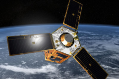
The Pléiades 1A satellite was successfully launched in December 2011 and its twin Pléiades 1B in December 2012 and provide 0.5m high resolution satellite image data.
These small (less than 1000 kg) and very agile satellites can rapidly change direction and perform a viewing angle in all directions. Moreover, they are located 180 degrees apart on the same orbit, so each site on Earth is visited at least once a day. The sensors are able to meet the needs of civil and military users, from mapping to urban monitoring, hydrology, geophysics and volcanology.
Pléiades high resolution sensor makes images in panchromatic mode with a resolution of 70 cm, which are resampled to 50 cm at ground level. In multispectral mode it shoots images of 2.8m resolution, which are resampled to 2 m. Merger of the two product types thus results in color images with a resolution of 50 cm.
Perhaps most importantly, Pléiades satellites are capable of acquiring high-resolution stereo imagery in just one pass, and can accommodate large areas (up to 1,000 km x 1,000 km). Image location accuracy can be improved even further, up to an exceptional 1 meter, by the use of GCPs.
Because the satellites have been designed with urgent tasking in mind, images can be requested less than six hours before they are acquired. This functionality will prove invaluable in situations where the expedited collection of new image data is crucial, such as crisis monitoring.
The Pléiades satellites feature four spectral bands (blue, green, red, and IR), as well as image location accuracy of 3 meters (CE90) without ground control points.
Bundle: 50-cm B&W and 2-meter multispectral
Spectral Bands:
- P: 480-830 nm
- Blue: 430-550 nm
- Green: 490-610 nm
- Red: 600-720 nm
- Near Infrared: 750-950 nm

